Gary Valle's Photography on the Run
Images taken on trail runs, and other adventures, in the Open Space and Wilderness areas of California, and beyond. All content, including photography, is Copyright © 2006-2011 Gary Valle. All Rights Reserved.
# Saturday, July 10, 2010

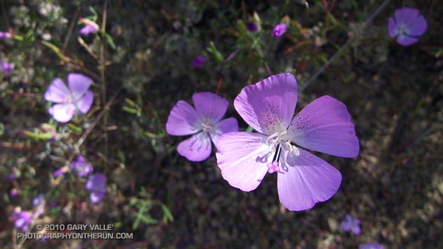
Speckled Clarkia (Clarkia cylindrica ssp. cylindrica) along the Garapito Trail in the Santa Monica Mountains, near Los Angeles.

Because they tend to bloom in late Spring and early Summer, this species of Clarkia and several others are sometimes referred to as Farewell to Spring.

From last Sunday's out and back run to Saddle Peak.

Related post: Elegant Clarkia

Saturday, July 10, 2010 8:35:28 AM (Pacific Daylight Time, UTC-07:00)  #   
# Friday, July 09, 2010

Unusual spider web in the Santa Monica Mountains


An unusual spider web, and the spider that made it.

Also from Sunday's out and back run to Saddle Peak.

Friday, July 09, 2010 3:29:33 PM (Pacific Daylight Time, UTC-07:00)  #   
# Tuesday, July 06, 2010

Leaves of climbing penstemon (Keckiella cordifolia)

Leaves of climbing penstemon (Keckiella cordifolia) on the Hondo Canyon Trail. Its seems to have especially benefited from our Winter rain, and its orange flowers are widespread in the chaparral this year.

From Sunday's out and back run to Saddle Peak.

Tuesday, July 06, 2010 2:42:31 PM (Pacific Daylight Time, UTC-07:00)  #   
# Sunday, July 04, 2010

Bay trees on the Hondo Canyon Trail

It was about 9:45 a.m., and I was switchbacking up through a surprisingly dense forest of California bay on the Hondo Canyon segment of the Backbone Trail. The trail was carpeted in bay leaves, and a hint of the sharp, sweet smell of bay lingered in the still morning air. It had been four years since I had run this trail, and I had forgotten just how lush and green it was. The geology, oaks, bay trees, ferns, and poison oak were spectacular.

Sunday, July 04, 2010 1:14:23 PM (Pacific Daylight Time, UTC-07:00)  #   
# Thursday, July 01, 2010

Thimbleberry blossom

From Sunday's run from Three Points to Waterman Mountain.

Thursday, July 01, 2010 3:24:54 PM (Pacific Daylight Time, UTC-07:00)  #   
# Sunday, June 27, 2010

Twin Peaks (East) from the Mt. Waterman Trail

Today was the first chance I had had to run the recently reopened stretch of the Pacific Crest Trail between Three Points and Cloudburst Summit. Originally within the Station Fire closure area, this segment of trail was reopened when the size of the closure area was reduced in late May. In addition to checking this section of the PCT, I also wanted to see the condition of the forest and trail at the current closure boundary near Mt. Waterman.

Pacific Crest Trail about a mile east of Three Points Between Three Points and Cloudburst Summit, the PCT generally parallels Angeles Crest Highway (Hwy 2), and crosses the highway several times. In general, the burn severity along the trail appeared to match the burn severity depicted in the NASA Ikhana BAER image and Angeles National Forest BAER Station Fire Soil Burn Severity Map. In the first two miles some trees were lost, but much of the forest in the immediate vicinity of the trail did not appear to be severely burned.

That was not the case about a half mile west of Camp Glenwood, where the PCT crosses Hwy 2 and climbs up a hill. Here the burn severity was much higher, and most of the trees were killed. The trail was in good shape and it didn't take long to get through this section and back into unburned forest. Remarkably, Camp Glenwood was unscathed.

The remaining 3 miles to Cloudburst Summit were not burned. Some trail work had been done on this stretch, as well as down in Cooper Canyon. As always, the running through Cooper Canyon was superb. At the PCT's junction with the Burkhart Trail I turned right and climbed up to Buckhorn Campground, and then followed the camp entrance road up to Hwy 2.  From here it was short jog west to the Mt. Waterman Trail.

Most of the forest of Jeffrey pine and incense cedar on the east side of Mt. Waterman was outside of the fire area, and it wasn't until near the junction with trail 10W04, that some damage from the fire could be seen. It looked like spot fires had run up the mountain, burning primarily in the understory. The north face of Twin Peaks, across from Mt. Waterman, appeared to be unaffected by the fire.

It is unclear why the Forest Service chose to define the updated Station Fire closure area (Forest Order No. 01-10-02) so that the trail to Twin Peaks remains closed. Based on the Forest Service's own BAER report, the burn severity down to Twin Peaks Saddle is generally categorized as low to very low/unburned, and the north face of Twin Peaks is outside of the burn area.

Some related posts: Cooper Canyon Cascade & Falls, Mt. Wilson Area Peaks From Twin Peaks

Sunday, June 27, 2010 2:44:56 PM (Pacific Daylight Time, UTC-07:00)  #   
# Saturday, June 26, 2010

Trail work on the Kenyon Devore Trail after the Station Fire.

Last year's Station Fire, and the Winter storms that followed, combined to damage many miles of trail in the San Gabriel Mountains. Among the volunteers working hard to restore the trails are runners that will doing the Mt. Disappointment 50K and Angeles Crest 100 mile endurance runs later this Summer.

Gary Hilliard, trail maestro and R.D. of the Mt. Disappointment runs, dedicates an astonishing amount of time to the task of preserving trails -- encouraging and organizing volunteers, surveying trails, and doing the down and dirty work of maintenance and restoration. If it's a Summer Saturday, chances are good you'll find him in Angeles National Forest, working with a group of runners to make a trail better.

Today's trail was the Kenyon DeVore Trail on the north side of Mt. Wilson. Originally a part of the Rattlesnake Trail, the trail was renamed in tribute to the Forest Service patrolman, hydrographer, and Angeles National Forest volunteer, Kenyon DeVore. The trail is the toughest part of infamous final leg of the Mt. Disappointment 50K and 50 mile courses, climbing about 2300' in 3.6 miles.

There was plenty to do on the Kenyon DeVore Trail, and Gary divided us into three groups. One group was given the job of restoring a long stretch of trail that had been obliterated by debris flows, and another group was assigned the chore of clearing a rock slide. Our group's task was removing several trees that had fallen across the trail, and working on the trail along the way.

The largest of the trees blocking the trail was a sizable bigcone Douglas-fir. At the point where it was cut, the diameter of the trunk was about 26"-28". For its size, the tree was surprisingly old. A rough count of the rings from a contrast enhanced photo gives an approximate age of 310 years. The age was not cross dated, but appeared reasonable when compared to a standard tree ring chronology.

The cut sections of the tree had no obvious fire scars. The CDF/FRAP Fire History Database indicated that, prior to the Station Fire, a large part of the canyon in which the tree was located had no reported fire history.

When we were done, about two-thirds of the Kenyon Devore Trail had been restored. No worries about the other third, Gary has trailwork scheduled most weekends through the end of July.

Saturday, June 26, 2010 3:23:58 PM (Pacific Daylight Time, UTC-07:00)  #   
# Friday, June 25, 2010

Wolf spider (probably Schizocosa mccooki)

I'd just run up the long hill we call "The Beast," and was running east on a relatively level stretch of gravelly dirt road on Lasky Mesa, when it's movement caught my eye.

My first thought was "Tarantula!" but this spider was slightly smaller than a tarantula, and running. Tarantulas walk, they (usually) don't run. This spider ran with a smooth, agile, articulated gait that must be the envy of the Arachnid world. I had never seen a spider like this, and started moving in its direction.

Lurking in the back of my mind was an experience I'd had with a tarantula, also on Lasky Mesa. In an attempt to redirect the tarantula from the margin of a dirt road, I'd blocked its intended path with my foot. This had worked a couple of times before, but this time the big spider briefly paused and  then continued to walk toward my running shoe. My shoe was on top of some dried oak leaves, in the grass on the side of the road. I thought maybe if I rustled the leaves... with lightning speed the tarantula charged my foot, and I jumped the proverbial mile.

Today I was going to have to react quickly if I was going to get a photograph. As I started moving toward this unusual spider, it saw me, and increased its speed. I continued to move in its direction, and it suddenly began a series of bizarre, defensive leaps. In a couple of seconds, the spider did three exaggerated "accordion" leaps, extending vertically to the full length of its impossibly long legs. The motion was somehow reminiscent of the propulsive action of a jellyfish. It was unexpected, and very effective!

After that the spider hunkered down, but seeing how quickly it had moved, I only took photos from a "respectable" distance. I wasn't real excited about putting my hand a couple of inches from its big fangs.

Saturday, I was running at Ahmanson with Brett, on Lasky Mesa, and shortly after telling him this story, he spotted the wolf spider (probably Schizocosa mccooki) pictured above!

Related post: Tarantula Time

Friday, June 25, 2010 9:28:38 AM (Pacific Daylight Time, UTC-07:00)  #   
# Wednesday, June 23, 2010

Mountain Phlox (Phlox austromontana)

Notice anything peculiar about the Mountain Phlox (Phlox austromontana) in this photo?

Usually 5-lobed, several of the blossoms here have six lobes.

These are along the Cougar Crest Trail, near Big Bear Lake. The photo is from a couple of weeks ago, the day before doing the Holcomb Valley 33 mile Trail Run.

The Havasupai reportedly use a preparation made from the plant (externally) for body aches.

Wednesday, June 23, 2010 8:16:29 AM (Pacific Daylight Time, UTC-07:00)  #   
# Sunday, June 20, 2010

Snow on the PCT below the summit of Mt. Baden-Powell.

Brett was down for Father's Day, and today we hiked/ran Mt. Baden-Powell (9399'). Baden-Powell is one of the most popular peaks in the San Gabriel Mountains, and several of my favorite trail runs visit its summit.

Lodgepole pine forest The trail from Vincent Gap switchbacks up through an old-growth forest of Jeffrey pine, sugar pine, white fir and lodgepole pine. There are some impressive trees. The Wally Waldron Lodgepole Pine, near the summit, is estimated to be 1500 years old, and some limber pines in the area are thought to be even older.

Today, the weather was perfect for pushing the pace. Along the trail fresh green growth could be seen on limb tips of the white firs, and yellow wallflower, red paintbrush, and blue larkspur added a mix of color to the understory.

Not far from the trailhead we had seen fresh Vibram FiveFinger (VFF) tracks headed up the trail, and we were talking about the minimalist shoe. Today Brett was in conventional shoes, but on his home trails about half his runs are in VFFs. He was recounting how the specialists doing a video gait analysis had been blown away when he switched from regular running shoes to VFFs.

I had asked Brett how many miles he had logged on his VFFs, but before he could answer, our conversation was interrupted by a loud shout of "25!" from somewhere on the trail above. A couple of minutes later, and a bit closer, there was another shout of "24!"

Named after the founder of the scouting movement, Mt. Baden-Powell is the culminating point of the scout's Silver Moccasin Trail. Most summer weekends you'll find one or more youth groups on their way to the summit of Mt. Baden-Powell. This enthusiastic group was counting down and calling out the 38, 40 or 41 switchbacks (depending on the reference) on the way to the summit.

One of the more interesting hikers on the trail was a hard looking Royal Marine veteran that was thru-hiking the Pacific Crest Trail. Hoping to minimize snow issues on the high Sierra passes, he was a little behind the main wave of PCTers. He had stopped at Lamal Spring to fill some water bottles, and told of hellish temperatures in the desert.

Mt. Baldy from Mt. Baden-Powell Here the temps had been nowhere near triple digits, but a considerable amount of snow had melted in three weeks since I had last been on the peak. Even so, there were still some large patches of snow on the steep slopes north of the summit, and on the north side of the ridge extending west to to Mt. Burnham.

After topping out, we hiked out along the scenic south ridge of the peak. To the southeast, across the mile deep chasm of Vincent Gulch, some ribbons of snow could still be seen on Mt. Baldy's north face. After a few minutes we returned to the summit, and began the much easier run down the peak. It was a great way to spend Father's Day!

Some related posts: Running Hot & Cold, Wally Waldron Lodgepole Pine, Bear Cubs on the South Fork Trail, PCT from Inspiration Point to Islip Saddle

Sunday, June 20, 2010 10:06:21 AM (Pacific Daylight Time, UTC-07:00)  #   
# Sunday, June 13, 2010

Jeffrey pine on the Cougar Crest Trail, near Big Bear Lake.

At aid station #2 we turned onto the Pacific Crest Trail, and followed the smooth single-track through a serene Jeffrey pine forest on the north slopes of Delamar Mountain. It was a little chilly and breezy at 7800', and the strong June sun felt good on my bare arms. I was at about mile 9 of the Holcomb Valley 33 Mile Trail Run and all was good. The subtle vanilla scent of the pines wafted through the trees, and here and there bright yellow blossoms of western wallflower seemed to mark the way.

Rounding a corner, a pine framed image of Big Bear Lake and snow covered San Gorgonio popped into view. Behind me, a runner exclaimed, "Gorgeous!" As she passed, she commented, "This is my favorite race!" And I can see why. Not only is the race well organized, with great aid stations and super helpful volunteers, it challenges the runner with a unique mix of terrain and altitude.

Sunday, June 13, 2010 3:52:51 PM (Pacific Daylight Time, UTC-07:00)  #   
# Saturday, June 12, 2010

Mt. San Gorgonio and the San Bernardino Moutains

Was up at Big Bear Lake this weekend for the Holcomb Valley 33 mile trail run. (More on that in a later post.) Got up to the lake around 2:00 in the afternoon, and on such a fantastic day couldn't just sit around.

First things first, I had to check out the trail on which the race would begin and end, the Cougar Crest Trail. The trail looked good. It wasn't too steep, and climbed up through an open forest of juniper, piñon pine, and Jeffrey pine. In hot weather the south facing trail would cook, but with morning temps in the 40's and afternoon temps around 70, that wouldn't be an issue. At about the mile mark the trail reached a level spot, and switchbacked left. It was a good point to turn around -- I'd see the rest tomorrow.

After a quick side trip to Holcomb Valley to check out another part of the course, I headed over to the Gray's Peak trailhead. It looked like this trail would have nice views of Big Bear Lake, and all the snow on north facing slopes of the San Bernardino Mountains.

With every switchback, this pretty trail tempted me higher and higher. I was torn between getting the scenic shot that seemed to be just around the next corner, and not overdoing it before the race. After a number of these switchbacks, I had to call it quits. I scrambled to a highpoint and took the photo above. Here's a larger image that shows the peaks a little more clearly.

The view framed by the trees extends from San Gorgonio Mountain (11,499') on the left, to San Bernardino Mountain (10,649') on the right. The peak just right of center, with the large snowfields, is San Bernardino East Peak (10,691'). One of my favorite trail runs climbs from Mill Creek on the other side of the range to San Bernardino East Peak, and then follows the crest to the summit of Mt. San Gorgonio. About 11 miles of the loop course is above 10,000'.

Related post: San Gorgonio High Line 2009

Saturday, June 12, 2010 12:37:23 PM (Pacific Daylight Time, UTC-07:00)  #