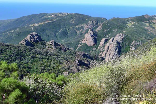
Gary Valle's Photography on the Run
Images taken on trail runs, and other adventures, in the Open Space and Wilderness areas of California, and beyond. All content, including photography, is Copyright © 2006-2011 Gary Valle. All Rights Reserved.
# Saturday, May 01, 2010

Crags below the Backbone Trail

The great view confirmed it -- we had run uphill. The new section of the Backbone Trail was so well-graded that the 850 feet of elevation gain from the trailhead at Encinal Canyon Rd. seemed almost effortless. For the next 14 miles, we would run through one of the most scenic areas of the Santa Monica Mountains; a rough and rugged highland with a character that might put it halfway around the world, rather than 35 miles from downtown Los Angeles.

Mariposas 
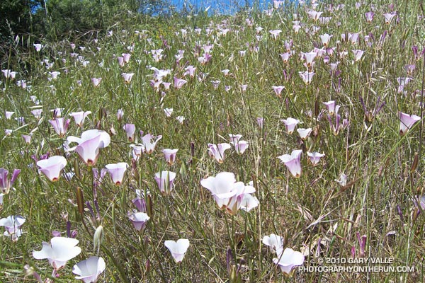
On this May Day morning, the canyons were cool, the sun warm, and the skies clear. From the craggy heights views extended from Catalina to the Channel Islands; and from Topa Topa to the San Gabriel Mountains. Winter rains had produced a profusion of wildflowers, accenting the trails with the whites, blues, yellows and reds of Spring.

It was an extraordinary day in which mile after mile of trail would pass underfoot with surprising ease. It was the best kind of training -- a run in which the training was an afterthought, and the focus was on the experience, rather than the logbook.

Here's an interactive Google Earth view of the 23 mile route from Encinal Canyon Rd. to PCH at Sycamore Canyon. The elevation gain on the run was about 2500 ft., and elevation loss about 3800 ft. Continuing to the Ray Miller trailhead by way of the Wood Vista, Overlook and Ray Miller trails would add about 3 miles and another 1000 ft. of gain. Another option would be to run through Serrano Valley to Sycamore Canyon. The Fireline Trail is a short distance down canyon from the Serrano Valley Trail, and could also be used to link to the Overlook and Ray Miller trails.

And here's a photo of the Yerba Buena segment of the Backbone Trail when it was under construction in 2003.

Related post: Boney Mountain Crags

Saturday, May 01, 2010 4:14:05 PM (Pacific Daylight Time, UTC-07:00)  #   
# Thursday, April 29, 2010

Encelia (bush sunflower) and cloud.

From today's trail run to Castle Peak in the western San Fernando Valley.

Thursday, April 29, 2010 1:24:41 PM (Pacific Daylight Time, UTC-07:00)  #   
# Wednesday, April 28, 2010

Rock Formation Along Cold Creek

From today's 8 mile trail run to Saddle Peak and back on the Stunt High and Backbone trails.

Wednesday, April 28, 2010 1:19:14 PM (Pacific Daylight Time, UTC-07:00)  #   
# Sunday, April 25, 2010

From today's run of a variation of the Boney Mountain Half Marathon course from Wendy Dr.

Related post: Above Satwiwa

Sunday, April 25, 2010 4:07:01 PM (Pacific Daylight Time, UTC-07:00)  #   
# Monday, April 19, 2010

This year's Kern River Festival had the best weather and water the event has seen for several years. Racers had a great flow for paddling the waterfalls, steep drops, and slides on Brush Creek; and boaters enjoyed paddling a challenging slalom course through the whitewater of Riverside Park in downtown Kernville.

A new event this year, the Hooligan Boat Race, was a spectator and participant favorite. Inspired by the event at the FIBArk River Festival, paddlers constructed their own boats out of "non-boat" materials and attempted to paddle their creations from upstream of the bridge in Kernville, down through the class II rapids in Riverside Park.

The photograph above is of "Al's Original Bucket Boat." Usually a bucket boat refers to a raft that isn't self-bailing, but in this case the boat is made of buckets, and the paddles from bucket lids.

As you might expect there were some outrageous designs, and not every boat made it to the finish line.

Next year the Hooligan Boat Race is expected to be even more popular. The Kern River Festival is held annually, the third weekend in April, in Kernville, California. In 2011 it is scheduled for April 16-17. (Easter is April 24, 2011.)

Monday, April 19, 2010 10:37:07 AM (Pacific Daylight Time, UTC-07:00)  #   
# Thursday, April 15, 2010

Chumash Trail Clouds

I heard a news report the other day that Southern California's rain season would end in two weeks. While Southern California typically receives the bulk of its precipitation in the months of November through April, the rain season doesn't turn off like a switch on May 1. There certainly can be significant rain in May, and even June.

The water year for Downtown Los Angeles (USC) is from July 1 to June 30 of the following year. So far, Downtown Los Angeles (USC) has recorded 16.17 inches of rain during the current water year. This is more than an inch above the 1971-2000 annual climate norm for Los Angeles of 15.14 inches.

Our Sunday-Monday storm put Downtown Los Angeles at 1.51 inches of rain for the month of April -- well above the climate normal of 0.83 inches. The normal amount of precipitation for May is 0.31 inches, and for June is 0.06 inches. But those are just averages. On occasion we receive much more than this, and sometimes much less. On the up side, according to NWS data, in April 1965 Los Angeles recorded a total of 6.02 inches of rain. In May 1921, 3.57 inches was measured; and in June 1999 0.98 inch was recorded.

Although the current El Niño has weakened, convection is still somewhat enhanced in a broad region of the equatorial Pacific, and the MEI, ONI, and GWO indicate the continued presence of El Niño. This could result in more active Spring weather than usual, and more opportunities for rain in Southern California.

At the moment, the next opportunity for some Southern California rain looks to be next week, around Tuesday or Wednesday. We'll see!

The title photo is from a run on the Chumash Trail at the end of March.

Thursday, April 15, 2010 8:42:53 AM (Pacific Daylight Time, UTC-07:00)  #   
# Monday, April 12, 2010

Chinese houses (Collinsia heterophylla)

Updated April 9, 2011.

Chinese houses (Collinsia heterophylla) along the Secret Trail in Calabasas, California. From a trail run on March 30.

Was originally identified as Davidson's Blue-Eyed Mary (Collinsia bartsiifolia var. davidsonii). Took a closer look at flowers in the same colony this year, including  the internal structure of the flower. The presence of a curved basal spur > 1 mm on the two upper (stamen) filaments;  corolla throat as wide as long; and calyx lobes generally sharp-tipped (per key in Jepson) distinguishes the species as the more common Collinsia heterophylla.

Monday, April 12, 2010 9:08:32 AM (Pacific Daylight Time, UTC-07:00)  #   
# Friday, April 09, 2010

One of the largest Southern Pacific Rattlesnakes I've seen at Upper Las Virgenes Canyon Open Space Preserve -- formerly Ahmanson Ranch. This one was on the East Las Virgenes Canyon Trail (aka Main Drag).

I counted 12 rattle segments, and as this HD video snapshot shows, the snake was nearly as long as the dirt road was wide.

From a run on Wednesday from the Victory trailhead to Las Virgenes Creek.

Friday, April 09, 2010 8:02:28 AM (Pacific Daylight Time, UTC-07:00)  #   
# Wednesday, April 07, 2010

Eagle Springs Fire Road, between the Hub and Trippet Ranch, in Topanga State Park

A couple of weekends ago, I was running up toward the Hub on Fire Road #30 with a couple of runners training for Leona Divide. One of them stopped suddenly, and pointed, "That's a scorpion!"

It was -- about an inch or so in length. I guess I shouldn't be surprised, but somehow I just didn't expect to see a scorpion out in the middle of a fire road, on a run to Trippet Ranch.

The title photo is a view from Eagle Springs Fire Road, between the Hub and Trippet Ranch, in Topanga State Park. Saddle Peak is in the distance.


Wednesday, April 07, 2010 2:12:07 PM (Pacific Daylight Time, UTC-07:00)  #   
# Monday, April 05, 2010

Annas hummingbird on showy penstemon, near Eagle Rock in the Santa Monica Mountains

Even though it was Summer, it was cold. Except for the clinking of our climbing gear, it was still and quiet at 13,000 ft. The sun had not yet risen, and I was perched on an icy step just below the bergschrund of Palisade Glacier. Tom had just crossed the large crevasse, and the brightly colored red rope ran through my hands as he worked up the ice of U-Notch couloir.

Monday, April 05, 2010 1:37:21 PM (Pacific Daylight Time, UTC-07:00)  #   
# Saturday, April 03, 2010

Catalina mariposa lily

From a run this week on the Secret Trail in Calabasas, California.

Saturday, April 03, 2010 12:37:35 PM (Pacific Standard Time, UTC-08:00)  #   
# Wednesday, March 31, 2010

Salomon XT Wings 2 Trail Running Shoe

Wow -- what a great ride! That was my impression the first time I used the Salomon XT Wings trail running shoe, and seven pairs and a couple thousand miles later, the XT Wings is still my shoe of choice for longer trail runs. Now the shoe has been upgraded to the XT Wings 2, and the good news is Salomon listened to the feedback from runners, and made a very good shoe even better.

XT Wings Comparison One of the most obvious changes in the XT Wings 2 is the change from an asymmetric speed-lacing system that would sometimes fray, to a symmetric speed-lacing system with lower friction eyelets. None of my Salomon trail shoes with symmetric lacing have had lace-fraying issues, and these new laces look bombproof!

Update 07/05/10. I now have about 190 miles on each of three pairs of Salomons with the the new eyelets (XT Wings, XT Wings 2 & XT Hawk 2), and I've had no problems with the laces fraying.

Not so obvious until you run in the shoe is the redesign of the toe cap to increase flexibility. I thought the gait transition was smooth in the original XT Wings, and it is even better now. I was also happy to find that my new pair of XT Wings 2 (US Size 9.0) weigh 26 oz., which is a bit less than my first pair of XT Wings.

The shoes felt great on Sunday's Trippet Ranch loop; they had that familiar XT Wings' combination of comfort, smooth ride, cushioning, traction and support.

Related posts: Salomon XT Hawk 2, Salomon XT Wings

Wednesday, March 31, 2010 9:50:31 AM (Pacific Standard Time, UTC-08:00)  #