Gary Valle's Photography on the Run
Images taken on trail runs, and other adventures, in the Open Space and Wilderness areas of California, and beyond. All content, including photography, is Copyright © 2006-2010 Gary Valle. All Rights Reserved.
# Sunday, October 11, 2009

Scrub oak apple gall.

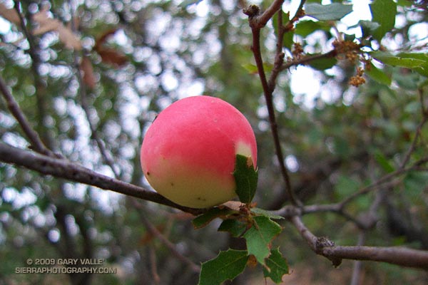
Almost incandescent in the soft light of an overcast sky, the remarkable color of this scrub oak apple gall contrasts sharply with the muted greens, grays and browns of the surrounding chaparral.

The gall forms in response to the larvae of the California gall wasp. The gall protects the developing larvae, as well as providing it a source of food.

On the right side of the gall there appears to be a "sun print" of an oak leaf in the red color, where a nearby leaf may have shielded the surface from sunlight.

From today's run on the Backbone Trail in the Santa Monica Mountains, near Saddle Peak.

Sunday, October 11, 2009 2:40:38 PM (Pacific Daylight Time, UTC-07:00)  #   
# Tuesday, October 06, 2009

Vibram FiveFingers KSO 

Updated February 10, 2010.

At one time or another, most of us have run barefoot -- on a beach or in a park, or certainly somewhere as a child.

As a result of the insight and enthusiasm of Barefoot Ted McDonald, and the publication of Christopher McDougall's book Born to Run, runners have been swept into a new era of minimalist running using Vibram FiveFingers (VFFs). Now a runner can, with VFFs and a little care, run trails virtually barefoot.

Tuesday, October 06, 2009 1:24:23 PM (Pacific Daylight Time, UTC-07:00)  #   
# Sunday, October 04, 2009

Sandstone Peak, the highest point in the Santa Monica Mountains.

We had been scrambling up the rocky north ridge of Boney Mountain for almost an hour. During that time the clouds along the crest seemed unable to make up their mind -- thickening, then thinning, gathering then dissipating. Now, as we climbed the final steep step to the crest, they were gathering and thickening once again. I wondered how difficult the route-finding was going to be in a pea soup fog.

The plan was to work up and over Tri-Peaks to Sandstone Peak, then backtrack on the Backbone Trail to the Chamberlain Trail, following it down into the Sycamore Canyon drainage. From there we would see.

Big Dome from Tri-Peaks, in the Boney Mountain Wilderness Cresting the top of the ridge, I paused to get oriented. Across the canyon, Tri-Peaks lay cloaked in clouds, with only its broad base visible from my vantage point. As we traversed along the cliff toward the peak's northern flank, nebulous patches of cloud whisked by, carried on a brisk breeze. Reaching a saddle, we wove our way through giant boulders and chaparral to the crags that form Tri-Peaks' summit.

As if passing through a hidden portal, the clouds dissolved as we worked over to the south side of the peak -- opening to a brilliant blue sky. Across the canyon, Big Dome had wrestled free of its tentacles of fog, and to the east, Sandstone Peak stood Everest-like, its summit wreathed in a veil of cloud.

It was a day energized with the zeal of Autumn -- a day to climb a peak, and then run down a mountain, across a valley, and over a distant horizon.

Some related posts: Sandstone Peak from Wendy Drive, Boney Mountain North Side Loop

Sunday, October 04, 2009 9:14:36 AM (Pacific Daylight Time, UTC-07:00)  #   
# Saturday, October 03, 2009

Windward side of a southern foxtail pine snag.

The windward side of this foxtail pine snag has been blasted by the icy winds of a multitude of Winter storms. The wind has sculpted the mineral-like wood, exposing and accentuating its inner layers.

The photo is from last Saturday's Cottonwood Pass - New Army Pass trail run. Nearly all of this route is above 10,000 ft. and 12 miles of it are above 11,000 ft. This relatively dry, high altitude habitat is home to the southern foxtail pine (Pinus balfouriana subsp. austrina).

One of the less common Sierra conifers, the tree is a long-lived species that is closely related to the bristlecone pine. The FEIS database references a southern foxtail pine 3400 years old, and the Gymnosperm Database a specimen with a crossdated age of 2110 years.

Because the tree grows so slowly, the wood is dense, and dead trees are slow to decay. In the vicinity of Cirque Peak, and a few other areas, dead foxtail pines and remnants are found above the current tree line. By crossdating tree ring sequences, a study published in 1997 found that over the past 3500 years the tree line in this part of the Sierra has generally been higher than it is now.

The study deduced that one period of reduced tree abundance and lowered tree line elevation was associated with warmer temperatures, and at least two severe multi-decade droughts. In contrast, the most recent decline has occurred during a cold, wet period that started about 450 BP.

It is remarkable that some of the dead foxtail pines studied here were alive during the Bronze Age, 4000 years BP.

Saturday, October 03, 2009 2:03:31 PM (Pacific Daylight Time, UTC-07:00)  #   
# Saturday, September 26, 2009

Descending from New Army Pass (12,300 ft.)

The flash of turquoise is so intense it is startling. The Mountain Bluebird flitters past, landing on a knobby plate of peppered Sierra granite. Its color is remarkable, without question a product of the mountains and the sky.

Cushion Buckwheat Nearby a yellow-bellied marmot waddles to a favored rock and watches us with a mix of reproach, curiosity and concern. Patience exhausted, he scurries into his den.

The wind is light and the sun bright. At 12,000 feet it is comfortably cool -- a perfect day for flying along the crest, scrambling among the rocks, or running a trail.

What better place to be on a fair Fall day than high in the Sierra?

Related posts: Siberian Outpost & Mt. Kaweah from the PCT, Cottonwood - New Army Pass Loop

Saturday, September 26, 2009 3:24:01 PM (Pacific Daylight Time, UTC-07:00)  #   
# Tuesday, September 22, 2009

Plastic Bottle Blight

It is everywhere.

From today's run in the Simi Hills, exactly as I found it, but not how I left it.

Tuesday, September 22, 2009 7:52:29 AM (Pacific Daylight Time, UTC-07:00)  #   
# Sunday, September 20, 2009

View west from Rocky Peak road, past Simi Valley to Boney Mountain.

Started the weekend with an exhilarating Morning Run in the Santa Monica Mountains near Saddle Peak, and wrapped it up with another enjoyable run, the Chumash - Hummingbird loop in the Santa Susana Mountains.

Prior to the start of a controversial condo development near Happy Face Hill, the Chumash - Hummingbird loop was a favorite of mountain bikers and trail runners. According to an article in the Simi Valley Acorn, the original developer abandoned the project in 2008, and the land was recently purchased by a new developer.

Hopefully any new construction plans will continue to include a trail connection from the Chumash trailhead on Flanagan Dr. to the Hummingbird trailhead on Kuehner Dr.

The title photo is a view west from Rocky Peak road, past Simi Valley to Boney Mountain.

Related post: Chumash-Hummingbird Loop

Sunday, September 20, 2009 8:42:35 AM (Pacific Daylight Time, UTC-07:00)  #   
# Saturday, September 19, 2009

From this morning's run on the Secret Trail, Calabasas Motorway, and the Stunt High Trail, in the Santa Monica Mountains near Los Angeles.

Saturday, September 19, 2009 12:25:51 PM (Pacific Daylight Time, UTC-07:00)  #   
# Friday, September 18, 2009


Click for interactive view using Google Earth plug-in.

Updated October 7, 2009. Added Sheep Fire Perimeter from GEOMAC and the approximate eastern boundary of the Station Fire Closure Area.

Here's an interactive Google Earth browser view of the approximate areas burned by the Station (2009), Sheep (2009), Morris (2009), Curve (2002), and Williams (2002) fires. The Station, Sheep and Morris fire perimeters are from the GEOMAC web site, and the Curve and Williams perimeters are from the CDF/FRAP web site.

The magenta line is the approximate eastern boundary of the Station Fire Closure Area as derived from Angeles National Forest Order No. 01-08-09, Exhibit A and Exhibit B. Please refer to the most current Forest Orders and Exhibits for official information.

GPS traces of some trail runs inside and outside the Station Fire area have been added, along with links to related photos and stories on PhotographyontheRun.com. Click on the green hiker icon to access the link.

The view also includes a partial track of the Pacific Crest Trail (2009 ver. 1) from the Pacific Crest National Scenic Trail web site.

Some placenames have also been added --the locations should be considered approximate.

This is a 3D view that can be panned, zoomed and tilted. See this help file for more info.

Related post: Station Fire MODIS Fire Detections

Friday, September 18, 2009 2:12:56 PM (Pacific Daylight Time, UTC-07:00)  #   
# Tuesday, September 15, 2009

Tarantula (Aphonopelma spp.) near upper Las Virgenes Creek

The second and third weeks of September is the time I'm most likely to encounter tarantulas in Upper Las Virgenes Canyon Open Space Preserve (formerly Ahmanson Ranch). Autumn is when maturing male tarantulas emerge from their burrows and wander in search of a mate.

This tarantula (Aphonopelma spp.)  was found near upper Las Virgenes Creek on today's wonderfully cool 8 mile "FiveFingers" run.

Tuesday, September 15, 2009 9:03:57 AM (Pacific Daylight Time, UTC-07:00)  #   
# Saturday, September 12, 2009

Fallen Jeffrey Pine in an area of downed trees located on the western end of the Vincent Tumamait Trail

I've run past this fallen Jeffrey Pine a number of times. It's in an area of downed trees located on the western end of the Vincent Tumamait Trail, near Cerro Noroeste road. The trees probably fell after being killed by a fire. It's a relatively large tree, and I've always wondered about its age.

A rough count of the growth rings gives an approximate age of 200 years. The tree ring sequence shows periods of fast growth, associated with above normal precipitation; and periods of slow growth, associated with drought.

Some related posts: Downed Trees Near Mt. Abel, Vincent Tumamait Trail

Saturday, September 12, 2009 3:31:16 PM (Pacific Daylight Time, UTC-07:00)  #   
# Tuesday, September 08, 2009

Runners Descending the Devil's Backbone on Mt. Baldy

It's a lot more fun working with gravity, than against it! For many runners, the run down from the summit of Mt. Baldy is as much a part of the Run to the Top experience as the race up.

Grueling sections of trail are effortlessly retraced, and there is more of an opportunity to enjoy the Devil's Backbone, and other spectacular sections of trail. Those needing more mileage skip the chair lift ride down from the Notch, and continue down the service road, following the route of the race.

Related post: Mt. Baldy Run to the Top 2009

Tuesday, September 08, 2009 8:06:40 AM (Pacific Daylight Time, UTC-07:00)  #