Gary Valle's Photography on the Run
Images taken on trail runs, and other adventures, in the Open Space and Wilderness areas of California, and beyond. All content, including photography, is Copyright © 2006-2010 Gary Valle. All Rights Reserved.
# Wednesday, December 03, 2008

Water droplets on the leaf segments of coffee fern (Pellaea andromedifolia).

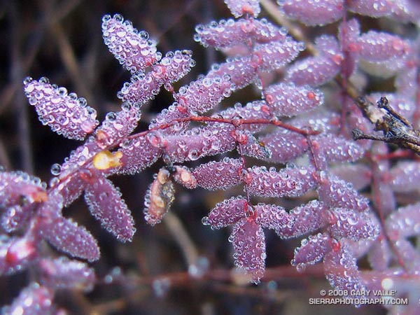
More delicate than the finest holiday crystal, the leaf segments of this coffee fern (Pellaea andromedifolia) are covered in tiny spherical water droplets. The largest of these droplets is about the size of the head of a pin, the smallest perhaps the size of a grain of salt.

Initially green, coffee fern turns various shades of red, brown, or purple with age.

From a run in the Boney Mountain Wilderness in Pt. Mugu State Park on Saturday.

Some related posts: T-storms and Trail Work, Return to Hidden Pond

Wednesday, December 03, 2008 9:10:37 AM (Pacific Standard Time, UTC-08:00)  #   
# Wednesday, November 26, 2008

Clearing clouds, northwest of Los Angeles, following the passage of an upper low storm system that resulted in widespread rainfall in Southern California.

Clearing clouds, northwest of Los Angeles, following the passage of an upper low storm system that resulted in widespread rainfall in Southern California. Several rainfall records for November 26 were broken in Los Angeles County.

Update 12/5/08 P.M. High amplitude flow continues to wreak havoc with forecasts. Our on-again, off-again chance of a shower this weekend might be on again. Original cut-off upper low center is still well offshore, but another low center has developed on the downstream side of high amplitude ridge, and this one is much closer to the Southern California coast. The low appears to be entraining some moisture, and could produce some showers, particularly as the low moves onshore and is absorbed in the main flow. We'll see!

Update 12/5/08 A.M. No rain is expected in SoCal this weekend... The cut-off upper low set up much further west than suggested by models Tuesday and now is spinning out in the eastern Pacific, nearly halfway to Hawaii. At the moment, it looks like it could be mid-month before our next chance for significant rain.

Update 12/2/08. Computer models have been having a tough time with both the short and medium term forecasts for Southern California. Recent runs have been hinting at the possibility of some rain Saturday or Sunday. This would depend on the strength, position and behavior of an upper low that is forecast to form off the Southern California coast Thursday.

From a run at Sage Ranch Park, near Simi Valley, California.

Wednesday, November 26, 2008 1:20:17 PM (Pacific Standard Time, UTC-08:00)  #   
# Sunday, November 23, 2008

The West Fork San Gabriel River at the Rincon-Edison road crossing.

We stopped for a few moments at the river crossing, where water stood in pools waiting for Winter rain. Instead, cold air flowed down its course, cool and refreshing. From this point there would be little shade. Rarely cold, the climb out from the West Fork San Gabriel River to Shortcut Saddle is often warm, and sometimes debilitating.

Sunday, November 23, 2008 12:32:35 PM (Pacific Standard Time, UTC-08:00)  #   
# Saturday, November 15, 2008

Moonrise at Ahmanson Ranch, now Upper Las Virgenes Canyon Open Space Preserve.

From a run at Ahmanson Ranch, now Upper Las Virgenes Canyon Open Space Preserve, Wednesday evening.

Saturday, November 15, 2008 9:23:21 AM (Pacific Standard Time, UTC-08:00)  #   
# Tuesday, November 11, 2008

Shell impressions on the Fossil Trail in Pt. Mugu State Park.

The Fossil Trail is a steep, approximately mile-long trail in Pt. Mugu State Park that connects the Upper Sycamore Trail, near its junction with Sycamore Canyon Road, to the Old Boney Trail. The most obvious fossils are shell impressions and remnants found in an exposed layer of sandstone about a tenth of a mile below the Old Boney Trail junction. Some of the shell impressions are palm-sized and larger.

The shells appear to be a type of cockle (Anadara devincta) that is an indicator of Miocene-age formations. (See the Oregon Sea Grant publication "Fossils You Can Find on Oregon Beaches.")  In this case, the fossil exposure appears to be in the Lower Topanga Formation, which is believed to have been formed in the middle to early Miocene, about 20 million years ago.

The shape, thickness and ribbing of this type of shell increases its strength and resistance to crushing -- improving the shell's chances of remaining intact when buried in sediment, and during subsequent geologic processes. This may be one of the reasons it is a prevalent indicator fossil.

The photograph is from Sunday's run from Wendy Drive to Serrano Valley.

Tuesday, November 11, 2008 4:16:53 PM (Pacific Standard Time, UTC-08:00)  #   
# Sunday, November 09, 2008

Descending to Serrano Valley in Pt. Mugu State Park

Scruffy clouds clung to the mountain ridges and summits, confirmation that a weak cold front was moving through the area, cooling temperatures and stirring up the wind. The forecast for the Santa Monica Mountains National Recreation Area had mentioned 25 to 35 mph winds with gusts to 60 mph. So far the weather in Pt. Mugu State Park had been nearly perfect -- breezy and little chilly, but without the impenetrable winds that can take all the joy out of running.

Sunday, November 09, 2008 4:05:09 PM (Pacific Standard Time, UTC-08:00)  #   
# Thursday, November 06, 2008

Terminal budding in yerba santa 3 weeks after the 2008 Sesnon Fire.

Only three weeks after the area was burned in the 2008 Sesnon Fire, this yerba santa shrub on the Chumash Trail has started the process of foliage replacement. In many areas along the trail, grasses and other annuals (many invasive) were consumed, but adjacent chaparral shrubs were only scorched. Many of these shrubs look like they will be able to recover through budding of existing stems, rather than crown-sprouting.

Some related posts: Chumash Trail - Sesnon & Simi Fires, Rocky Peak After the Sesnon Fire

Thursday, November 06, 2008 7:57:38 AM (Pacific Standard Time, UTC-08:00)  #   
# Sunday, November 02, 2008

A view of the eastern end of Simi Valley from Rocky Peak.

A view of the eastern Simi Valley and Simi Hills from Rocky Peak.

From a run in Rocky Peak Park today.

Sunday, November 02, 2008 8:39:59 AM (Pacific Standard Time, UTC-08:00)  #   
# Saturday, November 01, 2008

Old Boney Trail in the Boney Mountain Wilderness

When I woke to the rumble of thunder, rain pounding the roof, and wind roaring in the trees, I wondered if a planned run of the Boney Mountain Half Marathon course with John Dale was going to turn into an epic. Radar and satellite imagery showed subtropical moisture streaming in from the southwest, producing bands of showers and thunderstorms. Things don't always look as bad at the trailhead as they do on weather radar, so I grabbed my gear and headed for Wendy Drive.

Saturday, November 01, 2008 11:50:44 AM (Pacific Standard Time, UTC-08:00)  #   
# Friday, October 31, 2008

Downtown Los Angeles (USC) happened to be under the right cloud yesterday, and recorded 0.02 inch of rain. There's a continuing chance of showers in Southern California through the weekend. The area could use some rain. The last storm to produce more than a couple tenths of inch of rain at Downtown Los Angeles was back on February 24, 2008 -- more than eight months ago.

Last year, California's rain season might have been scripted by Dr. Jekyll and Mr. Hyde. Lowland rain totals and the Sierra snowpack were well above normal through the end of February, and then the spigot was turned off. The storm track shifted north, and California had its driest March to May on record. (The March 29, 2008 post in Ed Berry's Atmospheric Insights blog describes the events that may have led to and maintained this shift.)

Which rain season personality will surface this Winter? Earlier this year the equatorial Pacific tried to transition to El Nino, but the atmosphere didn't cooperate. As measured by the Multivariate ENSO Index (MEI), the ENSO state has returned to the weak La Nina threshold. And as measured by the Global Wind Oscillation (GWO), an uncooperative atmosphere has continued to cycle through a La Nina base state.

This suggests a winter precipitation outlook with a La Nina flavor -- similar to last year. This precipitation map, generated by the ESRL-PSD Composite ENSO plots page, shows the mean November-March precipitation for the U.S. during 9 La Niña events from 1948 to the present. The average La Niña rainfall indicated for coastal Southern California is in the 7.0-10.5 inch range. Last season's November-March rainfall in Downtown Los Angeles was about 12 inches.

Here's the current Nov-Dec-Jan precipitation outlook issued October 16 by the Climate Prediction Center. The "EC" means an equal chance of below normal, near normal, or above normal precipitation. The IRI Multi Model Seasonal Forecast for Nov-Dec-Jan is similar. We'll see what we get!

Friday, October 31, 2008 8:16:04 AM (Pacific Standard Time, UTC-08:00)  #   
# Sunday, October 26, 2008

View southeast toward Porter Ranch from the summit of Rocky Peak following the Sesnon Fire.

My run to "Fossil Point" on Rocky Peak road, and side trip to Rocky Peak, was not the appalling experience I've come to expect when investigating a wildland area that has been overrun by a Southern California brush fire. Much of the chaparral along the fire road was not burned. Here are a few photos:

View southeast toward Porter Ranch from the summit of Rocky Peak (larger image).

View north toward Rocky Peak where the trail levels out, about 1.4 miles from the trailhead.

Burned area near viewpoint of Simi Valley about 2.3 miles from the trailhead.

View north from the summit of Rocky Peak. Rocky Peak fire road is on the far left, and the Johnson trail is on the right.

Unburned area along Rocky Peak fire road about 2.8 miles from the trailhead. Rocky Peak is the peak on the left.

False color image of slopes on the southwest side of Blind Canyon. The image has been modified to emphasize burned and unburned areas.

Some related posts: Chumash Trail - Sesnon & Simi Fires, San Fernando Valley from Rocky Peak

Sunday, October 26, 2008 6:28:15 AM (Pacific Standard Time, UTC-08:00)  #   
# Friday, October 24, 2008

Scorched yerba santa along the Chumash Trail.

This weather worn sandstone boulder is a familiar landmark to those who do the Chumash Trail. It's a little less than a mile up the trail, and is at the point where the trail turns east and continues its climb along a cobble strewn divide. The chaparral here and elsewhere along the Chumash Trail was burned last week by the western flank of the Sesnon fire.

Friday, October 24, 2008 4:43:48 PM (Pacific Daylight Time, UTC-07:00)  #