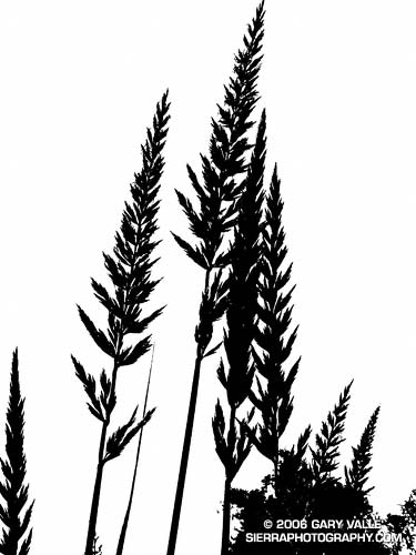
Gary Valle's Photography on the Run
Images taken on trail runs, and other adventures, in the Open Space and Wilderness areas of California, and beyond. All content, including photography, is Copyright © 2006-2008 Gary Valle. All Rights Reserved.
# Friday, May 26, 2006

Rock formation northwest of the Chumash Trail.
Rock Formation Northwest of the Chumash Trail

Practically any objective can make a good excuse for an adventure. Each time up or down the Chumash Trail, I pondered the prominent rock formation northwest of the trail, and wondered what I might find there.
Friday, May 26, 2006 1:49:20 PM (Pacific Daylight Time, UTC-07:00)  #   
# Tuesday, May 16, 2006

Tracks of runners, mountain bikers, a hiker, a rattlesnake, a wind-blown grass seed, and a motorcycle on Laskey Mesa.

Runners, mountain bikers, a hiker, a rattlesnake, a wind-blown grass seed, and a motorcycle -- all up on Laskey Mesa in Upper Las Virgenes Canyon Open Space Preserve (formerly Ahmanson Ranch).

Tuesday, May 16, 2006 7:49:34 AM (Pacific Daylight Time, UTC-07:00)  #   
# Saturday, May 13, 2006

Owl's Clover, in this case Castilleja exserta, is a fairly common California native.

A close view of Owl's Clover reveals the probable reason for the name -- fat little purplish-pink owls, crowned with a tinge of yellow, perched amid the purplish-pink of this unusual blossom.
Saturday, May 13, 2006 9:55:40 AM (Pacific Daylight Time, UTC-07:00)  #   
# Wednesday, May 10, 2006

Part of the Panorama from Olancha Peak.
Part of the Panorama from Olancha Peak

Olancha Peak (12,123 ft.) is the prominent, pyramidal peak seen on the Sierra crest from Hwy 395, south of Olancha. Its rocky summit is above tree line, and in some years snow can persist in the east-facing summit gullies and other sun-protected areas into late June, or early July.
Wednesday, May 10, 2006 9:34:04 AM (Pacific Daylight Time, UTC-07:00)  #   
# Monday, May 08, 2006

Sunset at Sage Ranch Park, a few weeks following the Topanga Fire.


Sunset at Sage Ranch Park, a few weeks following the Topanga Fire. The loop at Sage Ranch is about 2.4 miles. My usual route here is an out and back of about 4.5 miles. It's a good short-day run with an elevation gain/loss of about 700 ft. (Photo from a run on November 14, 2005.)
Monday, May 08, 2006 8:20:55 AM (Pacific Daylight Time, UTC-07:00)  #   
# Friday, May 05, 2006

Leaf of Milk thistle (Silybum marianum).


Milk thistle (Silybum marianum) is an aggressive invasive species not native to California. In Upper Las Virgenes Canyon Open Space Preserve (formerly Ahmanson Ranch) it seems to be increasingly abundant, particularly in the aftermath of the Topanga Fire. Last year, in some areas of Upper Las Virgenes Canyon, it grew thick as corn and more than head high.

Friday, May 05, 2006 7:51:50 AM (Pacific Daylight Time, UTC-07:00)  #   
# Thursday, May 04, 2006

Lichens on Chatsworth Formation sandstone at Sage Ranch.

Lichens are composite lifeforms, usually comprised of a fungus and algae, or a fungus and cynobacterium. Generally, the fungus provides shelter and needed minerals, and the algae, using photosynthesis, provides food. This community is on Chatsworth Formation sandstone at Sage Ranch.

There is a tendency to think of living things, including ourselves, in the singular. But most life is a intertwined assemblage of cooperating organisms, from the very small to the very large, living in harmony. Circle within circle, life within life.

Thursday, May 04, 2006 9:26:36 AM (Pacific Daylight Time, UTC-07:00)  #   
# Saturday, April 29, 2006

This photograph was taken October 23, 2005, on one of my favorite loops in the San Gabriel Mountains. This adventurous route starts at Islip Saddle, follows the South Fork trail down to South Fork Campground, then takes the Manzanita Trail up to Vincent Gap and the Pacific Crest Trail. From here, the PCT is followed up, and with a slight detour, over Mt. Baden-Powell, and then along the crest of the San Gabriels back to Islip Saddle. It's a very wild and scenic 23 mile run that covers a wide range of elevations. South Fork Campground is at 4,560 ft., and the summit of Baden-Powell is at 9399 ft. Total elevation gain and loss on the run is well over 5000 ft.

This year, it might make more sense to start this loop at Vincent Gap. In order to protect critical habitat of the mountain yellow-legged frog, the Forest Service has closed 1,000 acres in the upper Little Rock Creek drainage, including Williamson Rock, and the PCT between Eagle's Roost and the Burkhart Trail. In addition, Angeles Crest Highway (SR2) is now closed at Cedar Springs, just west of Eagles Roost.

Update May 27, 2007. Angeles Crest Highway (SR2) has since been re-opened to Islip Saddle. It was open to Islip Saddle on May 27, 2007, but closed beyond this point. It looked like the road past Islip was being resurfaced.

Following are links to PDF maps of the closure area and the PCT detour. For more information see the News section of the Angeles National Forest web site. For more information regarding the closure of Williamson Rock, see the Friends of Williamson Rock web site.

The post Wally Waldron Lodgepole Pine includes links to a Google Earth image and Google Earth KMZ file of this route.

PLEASE NOTE: The condition of certain sections of the Manzanita and South Fork trails is marginal, and rock slides and washouts may block the trail.

Saturday, April 29, 2006 3:02:20 PM (Pacific Daylight Time, UTC-07:00)  #   
# Thursday, April 27, 2006

A snow plant and other forest floor elements highlighted by a shaft of sunlight.

A snow plant and other forest floor elements highlighted by a shaft of sunlight. The photo was taken on a rambling out and back run of about 25 miles from the lower McGill trailhead to Mt. Pinos and Mt. Abel on July 24, 2005.

Here's a Google Earth image and Google Earth KMZ file of a GPS trace of my route.

For additional snow plant photographs, see the posts Three Points - Mt. Waterman Loop and Snow Plant, and also Snow Plant on SierraPhotography.com.

Thursday, April 27, 2006 8:30:22 AM (Pacific Daylight Time, UTC-07:00)  #   
# Tuesday, April 25, 2006

A totaled vehicle is an odd thing to find on a trail.

A totaled vehicle is an odd thing to find on a section of trail seemingly well away from any road.  In this case, Angeles Crest Highway (Hwy 2) is nearly out of sight and about a half mile up a very rough canyon. (Photo from October 23, 2005.)

Tuesday, April 25, 2006 8:08:24 PM (Pacific Daylight Time, UTC-07:00)  #   
# Monday, April 24, 2006

Honey Bee on Large Flowered Phacelia.

Like the Star Lily, Large Flowered Phacelia (Phacelia grandiflora) appears to be a "fire follower," blooming in the Simi Hills in the aftermath of the Topanga Fire.

Monday, April 24, 2006 8:26:40 AM (Pacific Daylight Time, UTC-07:00)  #   
# Friday, April 21, 2006

Juniper on the Middle Fork of the San Joaquin River.

This photograph was taken early in the morning in the canyon of the Middle Fork of the San Joaquin River, on a solo trail run from Agnew Meadows to Tuolumne Meadows in Yosemite National Park, in the Summer of 1986 or 1987. My route followed the river trail to Thousand Island Lake, and then the PCT over Island and Donohue Passes, and down Lyell Canyon to the Tioga Road. It was a wonderful and adventurous run in a stunning area.

Friday, April 21, 2006 9:40:48 AM (Pacific Daylight Time, UTC-07:00)  #