Gary Valle's Photography on the Run
Images taken on trail runs, and other adventures, in the Open Space and Wilderness areas of California, and beyond. All content, including photography, is Copyright © 2006-2008 Gary Valle. All Rights Reserved.
# Thursday, May 04, 2006

Lichens on Chatsworth Formation sandstone at Sage Ranch.

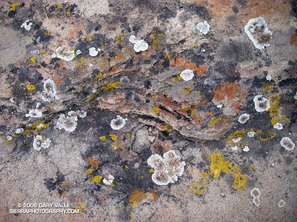
Lichens are composite lifeforms, usually comprised of a fungus and algae, or a fungus and cynobacterium. Generally, the fungus provides shelter and needed minerals, and the algae, using photosynthesis, provides food. This community is on Chatsworth Formation sandstone at Sage Ranch.

There is a tendency to think of living things, including ourselves, in the singular. But most life is a intertwined assemblage of cooperating organisms, from the very small to the very large, living in harmony. Circle within circle, life within life.

Thursday, May 04, 2006 9:26:36 AM (Pacific Daylight Time, UTC-07:00)  #   
# Saturday, April 29, 2006

This photograph was taken October 23, 2005, on one of my favorite loops in the San Gabriel Mountains. This adventurous route starts at Islip Saddle, follows the South Fork trail down to South Fork Campground, then takes the Manzanita Trail up to Vincent Gap and the Pacific Crest Trail. From here, the PCT is followed up, and with a slight detour, over Mt. Baden-Powell, and then along the crest of the San Gabriels back to Islip Saddle. It's a very wild and scenic 23 mile run that covers a wide range of elevations. South Fork Campground is at 4,560 ft., and the summit of Baden-Powell is at 9399 ft. Total elevation gain and loss on the run is well over 5000 ft.

This year, it might make more sense to start this loop at Vincent Gap. In order to protect critical habitat of the mountain yellow-legged frog, the Forest Service has closed 1,000 acres in the upper Little Rock Creek drainage, including Williamson Rock, and the PCT between Eagle's Roost and the Burkhart Trail. In addition, Angeles Crest Highway (SR2) is now closed at Cedar Springs, just west of Eagles Roost.

Update May 27, 2007. Angeles Crest Highway (SR2) has since been re-opened to Islip Saddle. It was open to Islip Saddle on May 27, 2007, but closed beyond this point. It looked like the road past Islip was being resurfaced.

Following are links to PDF maps of the closure area and the PCT detour. For more information see the News section of the Angeles National Forest web site. For more information regarding the closure of Williamson Rock, see the Friends of Williamson Rock web site.

The post Wally Waldron Lodgepole Pine includes links to a Google Earth image and Google Earth KMZ file of this route.

PLEASE NOTE: The condition of certain sections of the Manzanita and South Fork trails is marginal, and rock slides and washouts may block the trail.

Saturday, April 29, 2006 3:02:20 PM (Pacific Daylight Time, UTC-07:00)  #   
# Thursday, April 27, 2006

A snow plant and other forest floor elements highlighted by a shaft of sunlight.

A snow plant and other forest floor elements highlighted by a shaft of sunlight. The photo was taken on a rambling out and back run of about 25 miles from the lower McGill trailhead to Mt. Pinos and Mt. Abel on July 24, 2005.

Here's a Google Earth image and Google Earth KMZ file of a GPS trace of my route.

For additional snow plant photographs, see the posts Three Points - Mt. Waterman Loop and Snow Plant, and also Snow Plant on SierraPhotography.com.

Thursday, April 27, 2006 8:30:22 AM (Pacific Daylight Time, UTC-07:00)  #   
# Tuesday, April 25, 2006

A totaled vehicle is an odd thing to find on a trail.

A totaled vehicle is an odd thing to find on a section of trail seemingly well away from any road.  In this case, Angeles Crest Highway (Hwy 2) is nearly out of sight and about a half mile up a very rough canyon. (Photo from October 23, 2005.)

Tuesday, April 25, 2006 8:08:24 PM (Pacific Daylight Time, UTC-07:00)  #   
# Monday, April 24, 2006

Honey Bee on Large Flowered Phacelia.

Like the Star Lily, Large Flowered Phacelia (Phacelia grandiflora) appears to be a "fire follower," blooming in the Simi Hills in the aftermath of the Topanga Fire.

Monday, April 24, 2006 8:26:40 AM (Pacific Daylight Time, UTC-07:00)  #   
# Friday, April 21, 2006

Juniper on the Middle Fork of the San Joaquin River.

This photograph was taken early in the morning in the canyon of the Middle Fork of the San Joaquin River, on a solo trail run from Agnew Meadows to Tuolumne Meadows in Yosemite National Park, in the Summer of 1986 or 1987. My route followed the river trail to Thousand Island Lake, and then the PCT over Island and Donohue Passes, and down Lyell Canyon to the Tioga Road. It was a wonderful and adventurous run in a stunning area.

Friday, April 21, 2006 9:40:48 AM (Pacific Daylight Time, UTC-07:00)  #   
# Tuesday, April 18, 2006

Tarantula Hawk on narrow-leaf milkweed (Asclepias fascicularis Dcne.)

Tarantula Hawks are huge wasps that prey on tarantulas and trap door spiders. This one (a male) was on a narrow-leaf milkweed (Asclepias fascicularis Dcne.) at the start of the Chumash Trail in Simi Valley. Several good runs start at this trailhead, and many variations are possible. It's 2.6 miles up the trail to Rocky Peak Rd, and from there you can do out and backs north or south along the fire road, or loops via Las Llajas canyon, the Hummingbird Trail, or the Lower Stagecoach Trail. (Photo from a run on September 14, 2005.)

Tuesday, April 18, 2006 10:20:28 AM (Pacific Daylight Time, UTC-07:00)  #   
# Wednesday, April 12, 2006

Fall leaves on Bear Creek, an isolated tributary of Arroyo Seco Creek.

Bear Creek is an isolated tributary of Arroyo Seco Creek, north of Pasadena, in the San Gabriel Mountains. This photo was taken on a spectacular Fall day in upper Bear Canyon on a long trail run that started at Clear Creek Station. The route worked around the north side of Strawberry Peak to Red Box, down to the West Fork, up the Valley Forge trail on Mt. Wilson to Eaton Saddle, then through the Mueller Tunnel and past San Gabriel Peak and Mt. Lowe to Tom Sloane Saddle. From here it continued down into Bear Canyon, up the Gabrieleno Trail to Switzers, and then back to Clear Creek using the Nature's Canteen trail. (Photo from November 11, 2005.)

Related post: Strawberry - Bear Canyon Loop.

Wednesday, April 12, 2006 8:53:28 AM (Pacific Daylight Time, UTC-07:00)  #   
# Tuesday, April 11, 2006

A runner descends the trail below Palomani Pass (16,600 ft.) on a circuit of Mt. Ausangate (20,905 ft.) in the Peruvian Andes.

A runner descends the trail below Palomani Pass (16,600 ft.) on a Circuit of Mt. Ausangate (20,905 ft.) in the Peruvian Andes. Once acclimated, running at that altitude wasn't as bad as I thought it might be, and when you return home, those 10,000 ft. trails feel like you're running at sea level. The trip was arranged by my good friend Devy Reinstein of Andes Adventures and was unforgettable. (Photo taken July 23, 2003.)

Tuesday, April 11, 2006 1:14:37 PM (Pacific Daylight Time, UTC-07:00)  #   
# Monday, April 10, 2006

New sprouts of grass at Ahmanson Ranch less than a month after the Topanga wildfire burned 24,175 acres in the Simi Hills, northwest of Los Angeles.

New sprouts of grass at Ahmanson Ranch less than a month after the Topanga wildfire burned 24,175 acres in the Simi Hills, northwest of Los Angeles. More photos and information regarding the Topanga Fire can be found in my Coyote Oak Journal article The Topanga Fire, Part I: Rain, Wind and Fire. (Photo from October 25, 2005.)

Monday, April 10, 2006 12:18:44 PM (Pacific Daylight Time, UTC-07:00)  #   
# Sunday, April 09, 2006

Ferns along the Garapito Trail, Topanga State Park.

Ferns along the Garapito Trail, Topanga State Park.

Chaparral has been described as an elfin forest, and there is probably no better trail in the Santa Monica Mountains to see why, than the Garapito Trail. From the fire road near Eagle Rock, the trail seemingly dives into a tunnel of chaparral, and doesn't emerge until it ends at Temescal Fire Road, some 2.5 miles away.

This day I ran a 12 mile figure-eight course from the end of Reseda to Trippet Ranch via the Hub, and then returned via the Musch, Garapito, and Bent Arrow trails. Fire roads out-- trails back. A shorter option goes directly to the Garapito Trail via the Hub, and then returns via the Bent Arrow trail. This is about 7.5 miles. A longer option tacks on an out and back to Parker Mesa at Trippet Ranch.

Sunday, April 09, 2006 1:38:01 PM (Pacific Daylight Time, UTC-07:00)  #   
# Wednesday, March 29, 2006

San Fernando Valley from Rocky Peak

Updated May 3, 2008.

Whether it's raining, 100 degrees, or snowing (!) you're likely to see someone hiking, mountain-biking, or running Rocky Peak road in  Rocky Peak Park. Switchbacking up from the 118 freeway, the fire road climbs along the spine of the Santa Susana mountains. It's proximity to the San Fernando and Simi Valleys, and array of route variations, make it the choice of many for a morning or afternoon workout.

It's not because it's easy -- the route is steep from the start, gaining 500 ft. in the first three-quarters of a mile, and 1200 ft. in just over 2 miles.

Following are some approximate one-way distances and elevation gains.

Hummingbird Trail: 0.8 miles 500 ft.

High point at turnoff to peak: 2.4 miles 1200 ft.

Johnson Motorway: 3.2 miles 1350 ft.

Chumash Trail: 3.8 miles 1390 ft.

Fossils: 4.8 miles 1800 ft.

Las Llajas Loop turnoff: 5.5 miles 1950 ft.

End of Rocky Peak Rd at Las Llajas Cyn Rd.: 6.3 2070 ft.

Related posts: Chumash Trail Snow, Oat Mountain Snow, Sunset Snow Shower.

Technorati Tags: , ,

Wednesday, March 29, 2006 3:48:23 PM (Pacific Daylight Time, UTC-07:00)  #