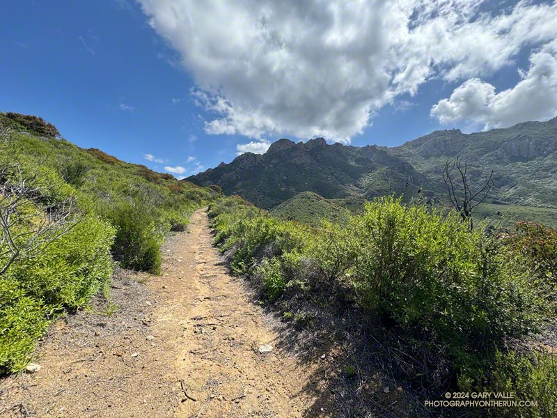
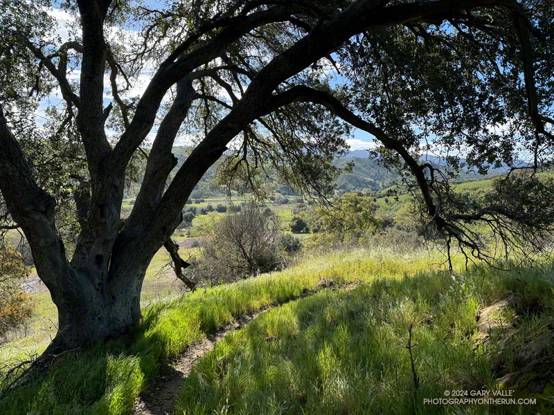
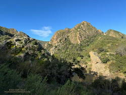
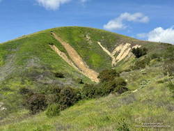
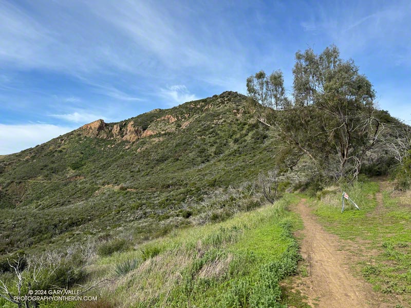
Western Ridge and escarpment of Boney Mountain from the Old Boney Trail
For months, it seems wet weather has had a particular affinity for Saturdays and Sundays. This has resulted in some wet, chilly runs. It’s also put a damper on other outdoor activities. A long-time rock climber, I enjoy going to Stoney Point and doing a circuit of easy bouldering problems. That’s been hard to do because 1) muddy climbing shoes don’t work so well, and 2) sandstone hand/footholds tend to break when wet.
That’s one of the reasons I was back on the western ridge of Boney Mountain — at least I’d get to climb something!
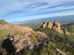
Near the halfway point on the Western Ridge.
Following a well-worn route, I scrambled up Boney’s western ridge to the crest and worked over Tri Peaks to the Backbone Trail. This time, after descending the Chamberlain Trail, I turned right (north) on the Old Boney Trail and looped back to where the western ridge route began. From there, I retraced my steps back to Wendy Drive. Here’s an interactive 3-D terrain map of my GPS track.
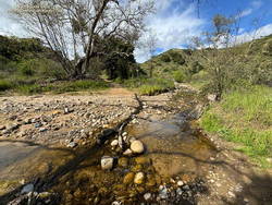
There were other reasons for doing this route. It’s been a very wet couple of years, and there is little trail infrastructure to handle the runoff from all the storms. Last weekend, another strong storm drenched Southern California, and on Friday, there was additional rain. The Boney – Old Boney route crosses just one creek (twice), and it usually has a decent limb/log/rock bridge. I suspected other routes would involve soaked socks and shoes.
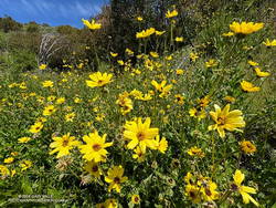
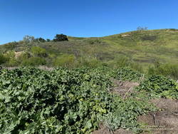
Bush sunflower along the Old Boney Trail.
I’d also read that the Santa Monica Mountains Trails Council (SMMTC) recently worked on the Old Boney Trail. After experiencing the challenges of brush on that trail firsthand, I was curious to see what the trail was like now. In addition, the Old Boney return has fantastic views of Boney Mountain’s impressive western escarpment. It’s fun to look up at where you’ve been!
Another consideration — not necessarily positive or negative — is the Boney Mountain – Old Boney keyhole loop has nearly a 1000′ more elevation gain than the similar length (16-mile) Blue Canyon, Sycamore Canyon, Upper Sycamore route.
Running south in upper Las Virgenes Canyon, I’d passed the connector to Cheeseboro Canyon and was nearing Las Virgenes Creek. Before reaching the creek, I turned left off the main road onto a path that has a log bridge across the creek.
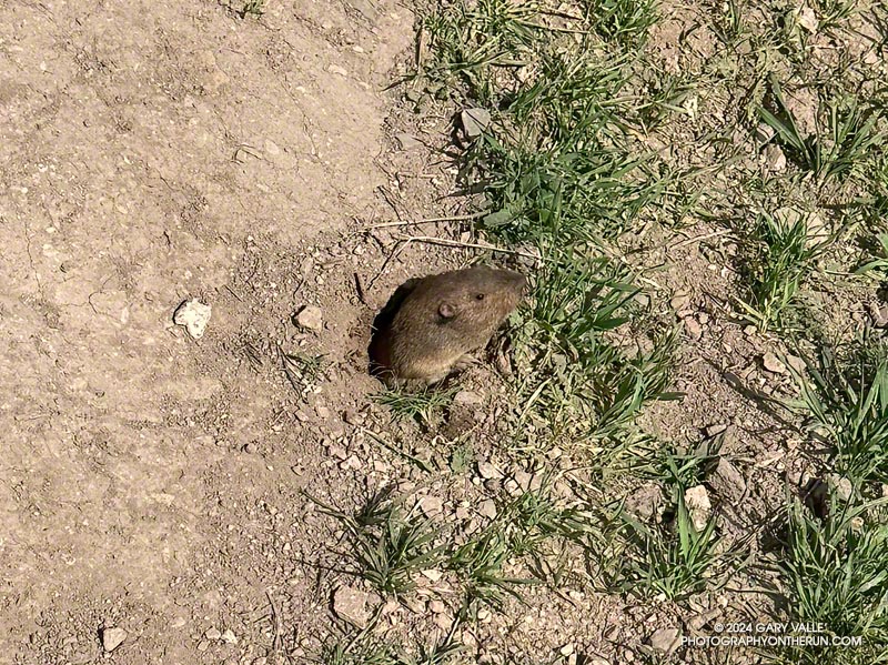
As I stepped onto the berm at the edge of the road, I caught a glimpse of something small and furry moving at my feet. I stopped and stepped back.
That’s when the vole poked its head from a burrow. I could almost see it squinting as it assessed whether or not I was a threat. Deciding to continue foraging, it emerged from the hole as far as it dared, and worked to free a small clump of grass at the margin of the burrow. Mission accomplished, in a flash of fur it returned to its burrow.
One of the e-mountain bikers commented, “That’s a lot of water!”
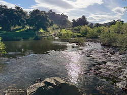
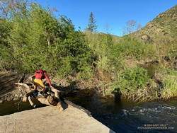
The three of us had arrived at the bank of Malibu Creek at the same time. There was a lot of water. The crossing must have been a real monster during some of this year’s storms, but this morning the creek was slow-moving and maybe 30-40 yards across. The main concern getting across would be slipping on the algae-covered rocks along the bottom and taking an unintended bath. I waded in.
Malibu Creek – the trail continues on the other side.
How did I find myself wading across Malibu Creek on this brisk March morning? I was doing a convoluted variation of the Phantom Loop, enjoying the Spring scenery, and going where the trails and terrain took me.
What is the Phantom loop? For me, it’s any loop that starts at the Cistern Trailhead on Mulholland Highway and ends at the Phantom Trailhead on the other side of the highway. Or vice versa. And since it’s a loop, it could start/end at any trailhead on or near the loop.
My run started on the Cistern Trail shortly after dawn. I’d run through Reagan Ranch and then up the Lake Vista Trail to the overlook for an early morning view of Malibou Lake. From the overlook, I’d continued east on the Lake Vista and Deer Leg Trails, enjoying the blooms of the Ceanothus, Hummingbird Sage, and bush poppy along the way.
Just before the Deer Leg Trail descends from the crest, I stopped at another overlook to take in Malibu Creek’s stunning terrain. From the viewpoint, I could see the coast redwoods along Century Lake. A few of the tall trees survived the 2011-205 drought and the 2018 Woolsey Fire, including one young naturally germinated tree. Now we’re in a rare wet cycle. The past two years are among the wettest on record for Los Angeles — good news for the remaining trees!
From the overlook of Malibu Creek, I ran down to the Yearling Trail, turned right (east), and in about a hundred yards was at the top of the Cage Creek Trail. I followed this short trail down to Crags Road and Malibu Creek.
Runner crossing a makeshift bridge across Malibu Creek.
From the matchstick bridge, I turned around and ran east on Crags Road, past the Cage Creek Trail and Century Lake, and then down the road to the junction of High Road and Crags Road.
When doing the Phantom Loop, I usually continue east under the oaks on High Road to the Grassland Trail. But this morning, in keeping with today’s theme, I headed across the bridge — in the direction of the Visitor Center — and looked for a sign marking the start of the Chaparral Trail.
Goat Buttes and Planet of the Apes Wall from the Chaparral Trail.
Wading into a stream is always a bit awkward. I decided to follow a rocky shoal where the water was about calf deep. As expected, the rocks were rounded and slimy. I didn’t have poles and the footing wasn’t the best, but I managed to get across without incident.
In a few steps, I was headed east and back on the route of the “standard” Phantom Loop. In about a tenth of a mile, I forked left off the main road and onto the Grasslands Trail.
I’m always surprised how quickly the squishiness of wet running shoes and socks goes away. (Today, I was running in Hoka Challenger ATR 7s with Injinji socks.) By the time I reached Mulholland Highway, my shoes and socks had air-dried and felt more or less normal. Crossing Mulholland Highway, I walked east a few yards and continued north on the North Grasslands Trail to the Liberty Canyon Trail.
I hadn’t run far in Liberty Canyon when I came to the Talepop Trail. It had been a long time since I had done the Talepop – Grasslands (Las Virgenes Fire Road) Loop. The hills were green, the sun shining, and the temperature perfect for running. What better time than now to get on it again? With the cool conditions, I had plenty of water to do the extra three to four miles and wouldn’t have to make a side trip to De Anza Park.
Las Virgenes Trai/Fire Road
The loop was as pretty as I remembered it. Initially following an undulating ridge, the Talepop Trail eventually winds down to the grassy valley to the east and intersects Las Virgenes Fire Road. A left (north) turn here goes to De Anza Park; a right turn traverses classic oak grassland and leads back to the southern end of the Liberty Canyon Trail.
After completing the Talepop Grasslands loop, the remainder of the run followed the usual route of the Phantom Loop. It continues about 1.5 miles north on the Liberty Canyon Trail, but before reaching the trailhead, it jogs left (west), goes over Liberty Creek, and around to a short trail that connects to the Phantom Trail at a group of eucalyptus trees. My route in this area can be viewed by using our high-resolution, interactive 3D viewer and zooming in on the area near the Liberty Canyon Trailhead.
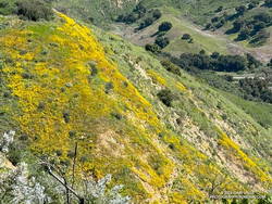
Hillside covered in wildflowers
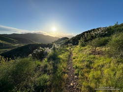
The Phantom Trail goes west up a canyon and then turns south, eventually reaching Mulholland Highway near the Cistern Trailhead. Once out of the canyon, the main trail crosses a use trail several times, so care must be taken to stay on route. The use trail more or less follows the ups and downs on the crest of the ridge, while the main trail switches from one side of the ridge to the other, avoiding unnecessary elevation gains.
The last time I ran this segment of trail — October 2023 — it was VERY overgrown (video). This time, thanks to the work of SMMTC volunteers, nearly all of the trail had been cleared. Many colorful wildflowers were in bloom on this stretch, including Ceanothus, Encelia, Wishbone bush, California poppy, owl’s clover, and paintbrush.
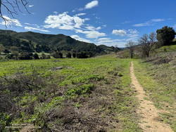
Following are some notes and photos from runs in Upper Las Virgenes Canyon Open Space Preserve (Ahmanson Ranch) during March 2024. Spring is here! The hills are green, goldfields and other wildflowers are blooming, and Las Virgenes Creek is flowing.
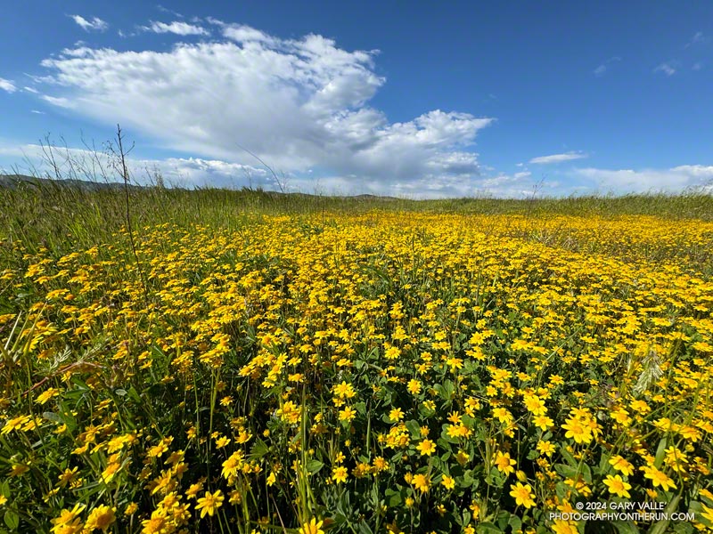
Goldfields and Other Wildflowers
The first goldfields (Lasthenia gracilis) of 2024 began to bloom on Lasky Mesa at the end of February. Now, bright yellow patches of these “belly” flowers are scattered across the mesa, adding a brush of color to the roads and trails of Ahmanson Ranch. The cheery flowers usually disappear with the first spell of hot and dry weather. Looking ahead, more rain and cool weather are forecast Easter weekend, and extended temperature outlooks are mixed. Hopefully, the goldfields will be around for a few more weeks.
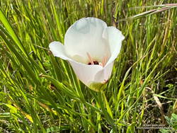
Catalina mariposa lily. Click to enlarge.
Some other wildflowers are also blooming. Blue Dicks usually flourish following a wet Winter, but this March are less widespread than usual. Red maids are also less numerous than normal and their flowers somewhat smaller. The elegant white flowers of Catalina mariposa lily are just starting to bloom.
After losing their leaves in December, the Valley Oaks at Ahmanson are now budding and sprouting. Some trees already have new leaves, while others are still bare-limbed. The period valley oaks are without leaves varies from year to year depending on rainfall, temperature, sunshine, and other factors.
Profuse rainfall is a two-edged sword. It revitalizes the ecosystem, turns the hills green, recharges the creeks, preserves the trees, produces wildflowers and more. But it can also be problematic — triggering slides, washing out and damaging trails, and promoting plant growth that chokes trails and increases the fire hazard.
At the moment, the roads and trails at Ahmanson are a bit rougher than normal, particularly in East Las Virgenes Canyon. Use and drier weather will gradually smooth out the ruts and rugosities, but we’re going to be picking foxtails from our socks for some time to come.
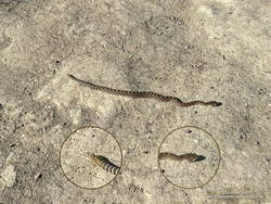
I sometimes stretch at the info kiosk at the Victory trailhead before running. Today, as I placed my hands against one of the kiosk posts and started to stretch, I glanced down. Disturbingly close to my feet was a small snake. Adrenaline flowing, I checked the head and tail and then checked them again. I stepped back and began to breathe. It was a gopher snake. But it could have just as easily been a rattlesnake. In fact, later on that run, I encountered a baby rattlesnake. That day and the next (March 20 and 21), I saw a total of four gopher snakes and two Southern Pacific rattlesnakes.
The Triunfo Peak Access trail forks off the Backbone Trail at a prominent eucalyptus tree.
Following more wet weather, I was back on the Backbone Trail and running in the direction of Mishe Mokwa from the Encinal Canyon trailhead. But this time, instead of going to Mishe Mokwa, I planned to do an out-and-back run to Triunfo Peak (2658′).
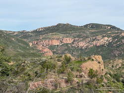
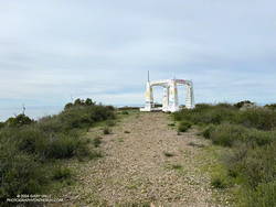
Echo Cliffs from Yellow Hill Fire Road on Triunfo Peak. Click to enlarge.
Whenever I’ve been on the Yerba Buena segment of the Backbone Trail, I’ve been curious about this peak. Situated on the crest of the Santa Monica Mountains, east of Sandstone Peak, it seemed like it might be an outstanding viewpoint, and I wasn’t disappointed.
About a half-mile up the Backbone Trail from the Encinal Canyon trailhead, I was surprised to be able to get a glimpse of the peak. Historic topo maps labeled the fire lookout on Triunfo Peak as “Triunfo Lookout” and now the peak is often referred to by that name.
Rock formations near the Grotto. Click to enlarge.
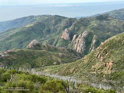
Thin high clouds veiled the sun and muted the scene as I descended the Backbone Trail to Yerba Buena Road. To the west Triunfo Peak/Lookout, Boney Mountain, and Sandstone Peak filled the skyline, their rocky prominences inviting further exploration.
According to the Former Fire Lookout Sites Register and Fire Lookouts websites, the lookout on Triunfo Peak was established in the early 1930s and taken out of service in the late 1960s. A steel lookout tower originally on Blue Ridge in Angeles National Forest was first moved to Bodle Peak around 1930, then moved and reassembled on Triunfo Peak in 1935.
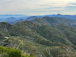
View east from Triunfo Peak along the crest of the Santa Monica Mountains. Click to enlarge.
A short connector trail is being constructed on the wet/northwest side of Trunfo Peak. When the trail is complete, it will connect the Backbone Trail to Yellow Hill Fire Road, near the summit of Triunfo Peak. The new trail will enable those doing the Backbone Trail to climb Triunfo Peak and return to the Backbone Trail without backtracking.
Rocky Peak Road is an exceptionally popular hiking and biking trail that starts at Santa Susana Pass, on the north side of the 118 Freeway. Regardless of the time of day or weather I ALWAYS see someone on this trail.
The plan for this afternoon’s run was to do an out and back on Rocky Peak Road to the top of the Chumash Trail (3.8 miles) or to Fossil Point (4.8 miles).
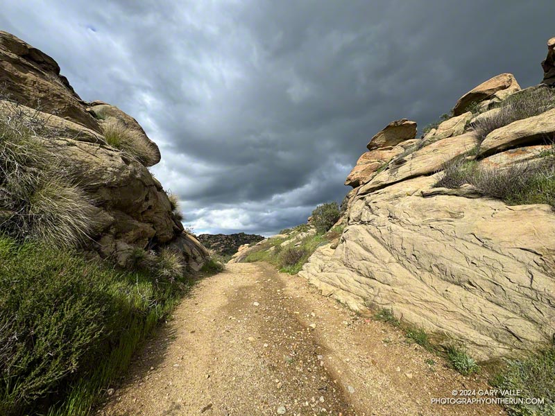
Another runner was finishing their workout as I started up the initial steep climb. Glistening in the warm sun, runoff from yesterday’s storm streaked some of the sandstone rocks, and ephemeral streams gurgled in the ravines and gullies.
Thanks to the sandstone geology, the dirt road wasn’t as muddy as most other local trails would be. Although heavily eroded from numerous Winter storms, it was still near the top of my list of places to run during periods of wet weather.
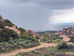
In the aftermath of yesterday’s storm the weather was spectacular. The temperature was warm enough to run in shorts and short-sleeves but still comfortable chugging up Rocky Peak Road’s steep hills. Puffy cumulus clouds filled the sky, creating postcard views at every turn.
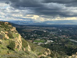
Clouds developing over the San Fernando Valley. Click to enlarge.
More focused about getting up the hill than any weather concerns, I continued past the top of the Hummingbird Trail and through a gap in the rocks to a section of road with a good view of the San Fernando Valley and San Gabriel Mountains.
I’d been in a situation similar to this several times on Rocky Peak. As a storm moves east from Los Angeles, energy circulating around the low can sometimes result in “back-door” precipitation. In this scenario, clouds build-up over the mountains to the north and then drift over the San Fernando Valley, producing showers — and sometimes — thunderstorms.
But today’s scenario was a bit more complicated. A much larger area, extending east to the San Gabriel Mountains, was rapidly destabilizing. What had been a picturesque sky at the start of the run was now congested and ominous. The question wasn’t so much if it was going to rain, but if a thunderstorm was going to develop.
As I continued up the road, the sky darkened, the temperature cooled, and the wind became more gusty and fitful. A little chilly, I pulled on my arm sleeves. I laughed nervously as I mistook the roar of a passing jet for thunder. That was a jet, right?
When people say they are “doing Rocky Peak,” they are often referring to a high point on Rocky Peak Road that is west of the actual peak and about 2.4 miles from the trailhead. The final climb to this high point is a good one — gaining about 450 feet over three-quarters of a mile.
The road on this stretch is oriented in such a way that the terrain hides the view to the north. I was anxious to get to the top of the hill so I could get a better idea of what the weather was doing. As I worked up the road, I would occasionally feel the cold splash of a raindrop on one leg or the other.
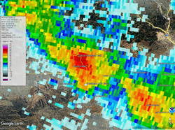
Doppler radar of strong thunderstorm over Rocky Peak. Click to enlarge.
Nearing the top, I thought, “I may get wet, but at least there’s been no thunder.” Within seconds of that proclamation, and as I reached the highest point, there was a long, loud, crackling peal of thunder.
One look at the sky and all thoughts of continuing to the Chumash Trail were gone. I turned around and started running down the hill, hoping to avoid the worst of the storm.
First one pea-sized hailstone hit the ground, then another, and then a sleety barrage of rain and hail poured from the sky. Instantly soaked, I shuddered as thunder echoed overhead and cold rain ran down my back. Muddy water flowed in rivulets down the sodden road and I cautioned myself to run fast, but not too fast.
I didn’t expect to outrun the storm, but hoped I might move to a part of it that was less intense. And that’s what happened. As I descended, the deluge gradually diminished. Most of the activity seemed to be behind me and a little to the east.
Severe thunderstorm moving into the Porter Ranch – Northridge area. Click to enlarge.
By the time I got down to the Hummingbird Trail, it was only sprinkling. The strong cell that had been over Rocky Peak had drifted southeast, and was now over the Porter Ranch – Northridge area.